| From | To | Distance | Ascent | Descent |
| Corryong Road | Mt Wills | 40 | 2054 | 1326 |
| Mt Wills | Mt Hotham | 77 | 3286 | 2808 |
| Total | 117 km |
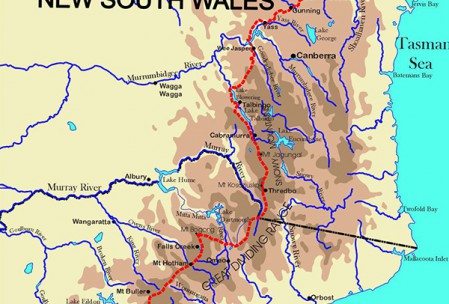
After Corryong Road the Alpine Track crosses Morass Creek before climbing across a small tableland and down to Taylors Crossing with its impressive suspension footbridge across the Mitta Mitta River. As the track climbs from Four Mile Creek up to Wombat Divide, majestic stands of mountain gums and alpine gums begin to appear. The track then drops again to Gill Creek and runs along an old mining road surrounded by lush temperate rainforest before starting the long climb up to the Omeo Highway and Mt Wills. This challenging climb past the empty site of the old gold town of Sunnyside is rewarded with spectacular views to all points of the compass from the fire tower at Mt Wills.
The track then wanders along Long Spur with more heart-grabbing views including, on the remote skyline, Mt Kosciusko and the Ramshead Range. Similarly, the views from Mt Bogong (highest peak in Victoria) make this a must-see detour. Next the track runs down to the exciting crossing of the Big River before climbing up from Big River to Ropers Hut to meander across the Bogong High Plains to more sensational views from Mt Nelse. The track soon reaches Langford Aqueduct for a level ramble along the eastern edge of the High Plains past a succession of High Country huts including the iconic Wallaces Hut
The track continues across the wide plateau of the Bogong High Plains and in spring, the wind-swept grasslands are thick with wildflowers while all around you, peaks poke their heads over the edge of the plateau. Feathertop to the west with its signature white flag streaming from its peak, Cope to the south and Mt Mackay to the north. Along the way you pass the stone cairns that marked the old gold miners’ track from Harrietville to Glen Wills and at the southern edge of the High Plain the track drops downs into Cobungra Gap with its Swiss-style hut – Dibbins. It then climbs Swindler Spur to Machinery Spur with its wonderful views across the deep valley of Murphy Creek to Hotham Village, the first sign of civilisation since Thredbo.
.

