| From | To | Distance | Ascent | Descent |
| Myponga | Mylor | 82 | 1299 | 1253 |
| Mylor | Adelaide | 69 | 1491 | 1764 |
| Total | 151 km |
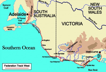
Yulte Conservation Park is alive with wildflowers in spring and there are some wonderful views across the Myponga Valley to Sellicks Hill Range before the Heysen Trail drops down to the Myponga Valley and runs through open paddocks to Hindmarsh Valley. Here it climbs onto an open ridge that provides wonderful views of the Southern Ocean and Gulf St Vincent. Along the way the Trail passes the remains of Mt Jagged Mine and eventually curves down into the broad upland valley of Compass Creek before climbing again to Mt Magnificent with its last view of the Southern Ocean and the Coorong before wandering north to reach Kuitpo Forest. For the next 30 kilometres the Heysen Trail winds through this forest and some pastoral country before wandering through Jupiter Creek Gold Diggings with its fascinating relics.
Mylor Conservation Park is an oasis of wildflowers and Stringybarks before the Trail follows footpads and quiet urban streets to Bridgewater where the Institute and Old Bridgewater Mill provide a colonial flavour. The trail then follows Cox Creek along an old headrace, through the shady, regenerated grounds of Arbury Outdoor School to the eucalypt forest of Mt George Conservation Park with its wetlands and wildflowers. Woodhouse Scouts Centre is soon passed and a stroll through the byways of Piccadilly takes the trail to Mt Lofty with its distinctive towers and the battlement of Carminow Castle. There are wonderful views to the east across Piccadilly Valley to Basket Range and at the top there are magnificent panoramas across Adelaide from Mt Lofty Lookout, the highest point on the Federation Track between Melbourne and Adelaide!
The Heysen Trail then wanders north along benched fire trails and quiet back roads to the quaint hilltop village of Norton Summit where it meanders down to the headwaters of Fourth Creek past ancient barns and antique vineyards to follow the creek through the extraordinary beauty of Morialta Gorge. Further north the vistas continue and at Black Hill the trail drops down to Torrens Linear Park. The primary purpose of this beautiful urban park is flood mitigation but it provides a green and shady avenue right into the heart of the city. River Red Gums flourish in the mown meadows to present a series of tree-scapes worthy of Heysen. Suburbia is never more than 400-500 metres away but, apart from the occasional bridge and O-bahn it is peaceful and pleasant. There are plenty of shaded seats and plenty of history – from the canoe trees of the Kaurna in Lochiel Park to reminders of the agricultural past at Athelstone Mill and “Lochend”. The Linear Park and Trail end at Hackney Bridge and parklands around Torrens Lake begin. This man-made lake is a reminder of Adelaide’s heritage. As you wander through this pleasant park, Adelaide Oval comes into view as do the buildings of Adelaide University across the river back-dropped by the towers of Adelaide CBD. Your river stroll ends at King William Road where you stroll past Elder Park and the Adelaide Festival Centre to the South Australian Parliament where the first session of the National Australasian Convention was held in March 1897.

